The Western Ghats are old, older even than the great Himalayan Mountain Range. They run from Gujarat in the north, all the way to Kerala in the south, with only a 30 kilometre-wide gap at Palakkad. They have nurtured societies and watched civilizations rise and fall.
The Western Ghats are no ordinary range – their forest ecosystems influence the Indian monsoon weather patterns that mediate the warm tropical climate of the region, presenting one of the best examples of the tropical monsoon system on the planet. The Ghats act as a key barrier, intercepting the rain-laden monsoon winds that sweep in from the south-west during late summer.
So why should you visit them?
This mountain chain is a UNESCO World Heritage site, and has been named one of the eight ‘hottest hotspots’ of biological diversity on the planet. The forests of the Western Ghats include some of the best representatives of non- equatorial tropical evergreen forests in the world. At least 325 globally threatened (IUCN Red Data List) species occur in the Western Ghats. The globally threatened flora and fauna in the Western Ghats are represented by 229 plant species, 31 mammal species, 15 bird species, 43 amphibian species, 5 reptile species and 1 fish species. Of the total 325 globally threatened species in the Western Ghats, 129 are classified as Vulnerable, 145 as Endangered and 51 as Critically Endangered. The Western Ghats are a natural wonder of the world, and Munnar is a great starting point to explore them.
Running parallel to the west coast, the Western Ghats, also known as Sahyadris, form the fluted western edge of the Indian peninsular plateau, which are stable Archaean and Pre-Cambrian formations (Nair, 1991).7 These mountains, making up around 4.8 percent of India’s land area, pass through the Indian states of Gujarat, Maharashtra, Goa, Karnataka, Tamil Nadu and Kerala. The average elevation is 1,200 m above MSL,that increases to around 2000 msl towards the south (NFC, 2006).8 The mountain ranges in the south also house the highest peaks south of Himalayas in India viz., Anaimudi (High Ranges), Misappuli Malai (High Ranges) and Doddabetta (Nilgiri Hills), at 2,695 m, 2,637 m and 2,634 m above MSL respectively (Daniel and Vencatesan, 2008).9
The Western Ghats harbor 27 percent of India’s floral wealth in a number of vegetation types including tropical wet evergreen, montane evergreen, moist deciduous, dry thorn & scrub forests and high altitude shola-grasslands ecosystems. Nearly a third of all flowering plant species of India are found here with around 1,500 endemic species of Angiosperms. Of the 490 arborescent taxa reported from the Western Ghats, as many as 308 are endemic and there are 112 endemic orchids among the 245 species. Overall, around 38 percent of India’s flowering plants and 63 percent of evergreen woody plant species are endemic to the Western Ghats. Many species are considered threatened, including 235 species of endemic flowering plants (NFC, 200610; Daniel and Vencatesan, 200811; MoEF, 200912). The Western Ghats is rich in faunal wealth as well with 189 species of fishes, 111 reptiles, 161 amphibians, 34 butterflies, 16 birds and 14 mammals as endemics. The Western Ghats is an Endemic Bird Area (EBA). The World Conservation Monitoring Centre (WCMC) has identified the Western Ghats as an important area of freshwater biodiversity (MoEF, 200913 and Molur et al., 201114) and has 39 biodiversity rich areas that are designated as a World Heritage site in 2012
Over 45 million people depend directly on the Western Ghats for livelihoods. Moreover, around 245 million people living in peninsular India receive most of their water from rivers originating in the Western Ghats (NFC, 2006).16 The density of population in the region varies from 100 to 300 inhabitants per km2.17
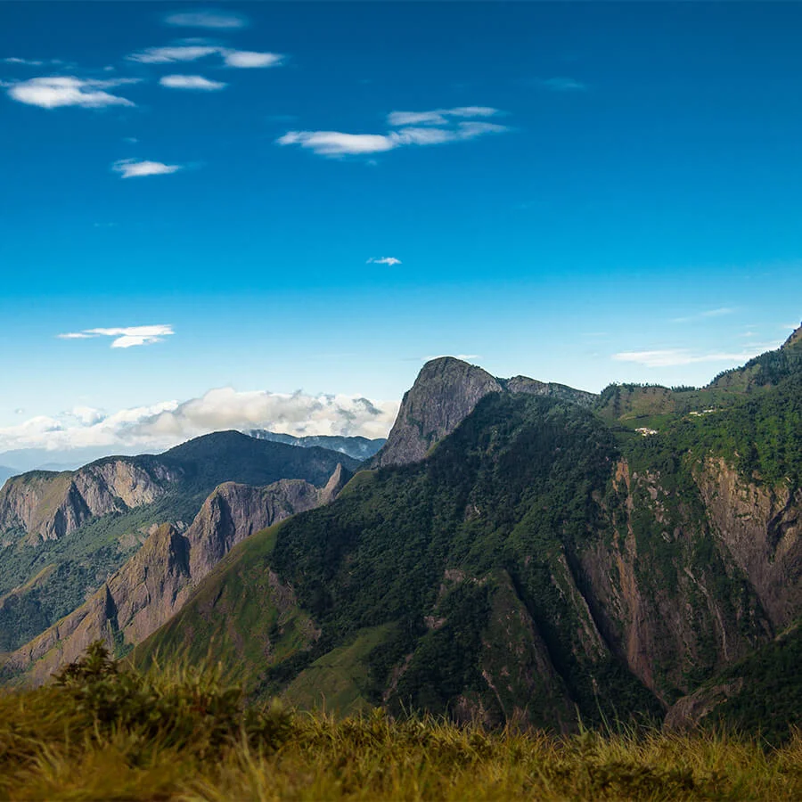
The high Kannan Devan Hills (KDH) and plateau around Munnar straddles Eravikulam, Anaimudi shola and Pampadum shola National Parks. They contain a matrix of shola-grassland ecosystems, Eucalyptus plantations and tea estates. Its eastern extremity merges into the Palnis through Vattavada valley and Kurinjimala Wildlife Sanctuary. The drier tracts of Anchanad Valley with its river head in the KDH and the east facing sholas drain towards Amaravathi River (tributary of Cauvery River) through Chinnar. The Idukki-Cardamom Hills stretch of the High Ranges is one of the widest reaches (about 45 km) in the Western Ghats and plays a crucial role in regulating weather and climate both within the landscape and also in an extensive area of Kerala and Tamil Nadu states. The ‘Unreserves’22 of Pallivasal and Chinnakanal have significant areas under shade cardamom and forest fragments harbouring an array of plant and animal species.
The sholas are a relict vegetation harboring species that have survived the climatic and ecological changes since the last glacial and may possibly be among the most endangered ecosystems in the world.
A noteworthy feature of the landscape is the occurrence of gregarious flowering (“outburst” once in 12 years) of the plant, kurinji (Strobilantheskunthianus) that literally carpets the grasslands giving them a veritable blue hue.
The richest biome in the entire Western Ghats, harbor the largest global population of the highly threatened Nilgiritahr and a significant population of Grizzled Giant Squirrel.